


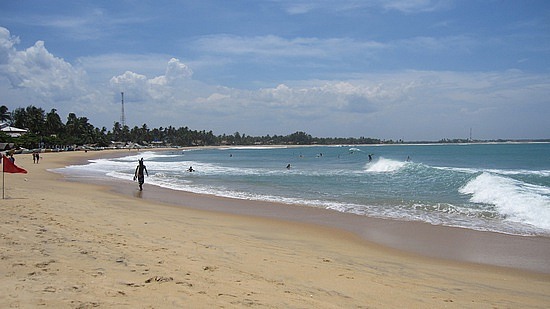
 Arugam Bay surf beach is located 314 km from Colombo, 2 ½ km south of the small town of Pottuvil in the Ampara district of Dry Zone South-east coast of Sri Lanka. Reaching Arugam Bay Sri Lanka Arugam Bay can be reached from Colombo via Moneragala in 7 hour drive along the A4 main road. Arugam Bay Beach Sri Lanka Arugam Bay Beach, a wide sweeping sandy beach in front of the village of Arugam Bay is an attraction for swimming all year-round. Arugam Bay's first international surfing competition was held by ISA (International Surfing Association) in the summer of 2004 despite the shocking destruction of the Tsunami On December 26, 2004, ISA returned again in 2005 to give the battered local economy of Arugam Bay a boost. The long, consistent right hand point break at the southern end of the Arugam Bay beach makes it the finest surf spot in Sri Lanka. Arugam Bay Beach with its coral reef being home to an abundance of tropical fish affords delightful snorkeling opportunities. Arugam Bay Surroundings The beach isn’t the only attraction at Arugam Bay. The countryside of the village of Arugam Bay brings about loveliest sceneries that span over mangrove, jungle, lagoon, river, rice fields and dunes. Over and above such a landscape is a pair of National Wildlife parks that are home to mammals including Elephants and rich in birdlife. Moreover, the historical and archeological site of Buddhist temple called Magul Maha Vihara reveals the history of the site with its stone inscriptions. Arugam Bay Surfing season The surfing season in Arugam Bay starts in April and ends in October. During the season the wind is predominantly offshore. Average water temperature: 28 degrees Average air temperature: 32 degrees Surf spots at Arugam Bay Arugam Point, a long right hand break close to Arugam Bay, which has (on a good day) 2m waves and a 400m ride. Thirty minutes north of Arugam Bay by three wheeler taxi, Potuvil Point, bit smaller than Arugam Point, breaks off a long sandy beach. South of Arugam Bay is another surfing point. Thirty minutes by three wheeler taxi and twenty minutes walk, Crocodile Rock, whenever there’s a sufficient swell, a fine spot for beginners and intermediate surfers. Pottuvil Lagoon in Sri Lanka Two kilometers inland from Arugam Bay is scenic Pottuvil Lagoon. Pottuvil Lagoon tour with a local fisherman is another joy at Arugam Bay: paddling out into the lagoon and through the scenic mangrove swamps vibrant with bird life, monitor lizards, crocodiles and elephants. Off-shore Dolphin viewing at Arugam Bay Beach The season for off-shore Dolphin viewing at Arugam Bay Beach is the period of May to September that falls within the high season of Arugam Bay: April to October. Two hour boat trip into sea affords the view of Dolphins. Panama 12km south of Arugam Bay is Panama, the last inhabited village that precedes the Yala East National Park. Panama that stays somewhat inland yet intersects with lagoons is rich in bird life. The wide beach that seams endless, the lagoon of Panama, the area surrounding it, sand dunes and rock boulders, all combine to make an enchanting landscape. While water buffaloes are seen wallowing in water bodies, an odd elephant too could be seen in savannah-like grassland. The pair of two huge rocky outcrops named Crocodile Rock and Elephant Rock at Panama, true to their names, are of resemblance to these creatures. Crocodile Rock, in addition to being a surfing spot, is also a favorite location of the wildlife lovers. So is the elephant rock; while the eagles sweep overhead, the elephants roam freely. Okanda Sri Lanka 20km south of Panama is the village of Okanda that has a popular surfing spot. The village is home to a famous shrine located at the point god Skanda is believed to have landed on the island. The shrine is the starting point of overland pilgrimage, the long walk to Kataragama for 15-day festival in July at Kataragama, the domain of god Skanda. Okanda is also the entrance point of the Yala East National park of which the mangroves and Kumana reservoir resulted in a high population of aquatic birds. Visit Yala East National Park Sri Lanka Although Yala East National Park is the twin of Yala West (Yala Ruhuna National Park), access from one to other is hindered by the River Kumbukkan Oya that flows separating these twin sanctuaries. Similar to popular Yala West in terrain, Yala East too is home to leopards and other mammals. The sanctuary supports a sizable elephant population, though herds are smaller than Yala West. Kumana Bird Sanctuary Sri Lanka Kumana Bird Sanctuary, fed by a channel from the River Kumbukkan Oya is the focal point of Yala East National park. About 20 km into the park is Kumana reservoir of which mangroves host a wide array of aquatic birds where many nest in May and June. Among the birds most seen are painted storks, herons, egrets, Indian darters and little cormorants. Black-necked stork, one of rarest birds of Sri Lanka could also been seen at the park. Kudumbigala Sri Lanka A few kilometers inland from Okanda lies the Kudumbigala forest hermitage. Hundreds of caves there had given shelter to the Buddhist monks as far back as the first century BC. Lahugala National Park Sri Lanka About 15km inland from Arugam Bay, the main road passes through the scenic Lahugla National Park. Extensive Lahugala reservoir being the center piece, Lahugala Park draws a population of about 150 elephants during July and August, when the surrounding water bodies dry up. In the lush vegetation and the grass which grows in abundance, the herds of elephants find their feed. The reservoir also brings about the spectacle of aquatic birds enjoying the company of elephants. Magul Maha Vihara, Lahugla (Yala East) Sri Lanka Just east of Lahugala lies a cluster of ruins of the ancient Buddhist temple called Magul Maha Vihara built by King Dhatusena (515-526 AD). With the ruins of dagoba, vatadage, image house and well-persevered doormats called moonstones the location within the jungle has become all the more evocative. |